Entries in Fire Needs Assessment (3)

Wednesday
Jun292016

Wisconsin Fire Needs Assessment Published

What are the priority areas for prescribed fire in Wisconsin? The Tallgrass Prairie and Oak Savanna Fire Science Consortium partnered with the SILVIS Lab at UW-Madison and the Lake States fire Science Consortium to conduct a Fire Needs Assessment (FNA) for Wisconsin. This project used LANDFIRE vegetation data (www.landfire.gov) to identify where fire-dependent vegetation is located and the fire return interval of community types.
 

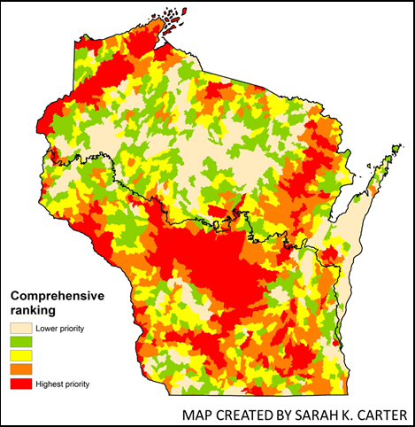
The assessment found that the highest priorities for management with prescribed fire occurred in the Central Sand Plains and Sand Hills, Northwest and Northeast Sands, and along the lower Wisconsin River. These areas reflect where high concentrations of rare ecosystems with frequent fire return intervals occur and there may be less challenges associated with applying prescribed fire in the Wildland Urban Interface.

To learn more:
1) View or download a two page PDF of the final report.
2) Email  corresponding author Tracy Hmielowski.
3) Access the article in Ecological Applications via:  http://dx.doi.org/10.1890/15-0509


Literature cited:  Hmielowski, T. L., Carter, S. K., Spaul, H., Helmers, D., Radeloff, V. C., & Zedler, P. (2016). Prioritizing land management efforts at a landscape scale: a case study using prescribed fire in Wisconsin. Ecological Applications, 26(4), 1018-1029. 

Thursday
Aug282014

Wisconsin Fire Needs Assessment

What are the priority areas for prescribed fire in Wisconsin?

The Tallgrass Prairie and Oak Savanna and Lake States Fire Science Consortia, in collaboration with researchers in the SILVIS lab at the University of Wisconsin at Madison, have completed an initial Fire Needs Assessment (FNA) for the state of Wisconsin. The goal of this project was to identify priority areas for management with prescribed fire, with a focus on fire dependent ecosystems with fire return intervals of less than 50 years. Using vegetation data from LANDFIRE, the State Wildlife Action Plan, Wildland Urban Interface data, and input from numerous stakeholder groups, a cost benefit analysis was conducted. This cost benefit analysis used the spatial data to identify where the ecological benefits of using prescribed fire are likely to be greatest when accounting for the effort and challenges of conducting prescribed burns. 

Figure 1. Priority Management Areas by Subwatershed Unit

The initial results show high priority areas in central and northwest Wisconsin, when summarized by subwatershed spatial units (Figure 1). There are also priority areas in the northeast and southern portion of the state, reflecting the occurrence of rare community types such as tallgrass prairie and oak barrens. The Consortia hope to work with fire managers across the state to use this assessment as both a statewide planning tool and a starting point for fine scale analyses of fire needs.

You can view or download a two-page PDF version of the FNA summary results.

If interested in learning more about the project, contact TPOS Fire Information Specialist Tracy Hmielowski.


Thursday
Aug282014

LANDFIRE Webinar Series

This post is now archived. LANDFIRE and Joint Fire Science Program (JFSP) consortia members developed a series of webinars that are designed to help land managers and others understand and use data resources to assist them when making decisions regarding large landscape projects.

Click to read more ...